Maritime Crime: Piracy, Smuggling, Wrecking and Watery Whodunnits (A one-day short course)

banner

The Greenwich Maritime Institute invites you to dive into a dark whirlpool of wrongdoing, past and present. Piracy, committed for private gain, is a form of maritime crime often in the headlines, but it is far from the only one. Led by Professor of Maritime Security Chris Bellamy, Dr Cathryn Pearce, author on wrecking, and Dr Helen Doe from Exeter University, an authority on smuggling, you will navigate through the depths of mankind’s misdeeds on the high seas, rivers and ashore.

The course will explore four main types of sea crime: piracy; wrecking; smuggling; and the wide variety of crimes committed aboard cruise ships, merchant ships and luxury yachts. Among the issues covered will be:

  • What is maritime crime?
  • Piracy then and now
  • Wrecking then and now
  • Smuggling then and now
  • Maritime murder

The course will take place on Wednesday 12th June 2012 from 9.30am – 4.30pm. The cost is £90 per person which includes lunch, refreshments, course materials and a certificate of attendance. A booking form can be found on the Greenwich Maritime Institute website: http://www2.gre.ac.uk/about/schools/gmi/study/short/programmes

Wreck image 250 pixels

A Leading Global Player: Maritime Business Activities in China (A one-day short course)

Slide1

The China Maritime Centre is holding a one-day course on Monday 10th June 2013 in Greenwich, UK.

Over the last decade China has become the leading influence shaping global seaborne trade, as result of a remarkable upsurge in trade volumes. This GMI short course will be led by the Director of China Maritime Centre Dr Minghua Zhao, international shipping analyst Richard Scott and researcher Yifan Liao who specialises in ship recycling. The aim of the course is to investigate how, and explain why, China has become such a prominent part of the global maritime scene within a relatively short period since the early 2000s, and to provide some clues about future trends.  

The course will focus on three specific areas of growth within the maritime industry in China:

 •China’s maritime trade and ports: a remarkable expansion

 •The rapidly growing China-owned merchant ship fleets

 •A new era for shipbuilding and ship recycling in China

The cost is £90 per person which includes lunch, refreshments, course materials and a certificate of attendance. A booking form can be found on the Greenwich Maritime Institute website: http://www2.gre.ac.uk/about/schools/gmi/study/short/programmes

shutterstock_29266564
Chinese Port

Wallasea Island and the Environmental History Group Field Trip

The Wallasea Island Site Visit

Please click here for a fuller PDF version of this blog

Wallasea Island was the site visited by our group of MA students on a beautiful sunny day last week. We’d been thinking about where best to go in the Thames estuary area to see in action some of the themes discussed in our environmental history course (Environmental History and the Sea: The British Isles, 1800 to 2013, part of the MA in Maritime History, at the Greenwich Maritime Institute). Wallasea was suggested by one of our students and turned out to be perfect. Political debates over port development, erosion and flooding, leisure and the coast: they’re all at Wallasea. It is here that the Royal Society for the Protection of Birds (RSPB) is developing its Wild Coast project: the largest ‘habitat creation’ scheme in Europe.

We were very fortunate to have the opportunity to meet up with the RSPB’s Wallasea Island Project Manager, Chris Tyas. He showed us the site and talked to us about the project’s three main inter-locking strands: Defra’s ‘Wallasea Wetlands Creation Project’, the RSPB’s Wild Coast Project, and the material provided by the Crossrail project.

Our group with the RSPB's Project Manager at Wallasea. © Vanessa Taylor, Greenwich Maritime Institute, 2013
Our group with the RSPB’s Project Manager at Wallasea.
© Vanessa Taylor, Greenwich Maritime Institute, 2013

 Wallasea Wetlands Creation Project: Allfleet’s Marsh 

Wetland 1
‘Managed re-alignment’ and the mudflats of Defra’s ‘Wallasea Wetlands Creation Project’. In the distant centre you can see places where the sea wall was breached in 2006.
© Vanessa Taylor, Greenwich Maritime Institute, 2013
Wetland 2
Looking north east across new salt marsh towards Crossrail’s unloading site (see below).
© Vanessa Taylor, Greenwich Maritime Institute, 2013

These mudflats and salt marshes are part of a new site – Allfleet’s Marsh – created by Dept of the Environment, Fisheries and Rural Affairs (Defra) in 2005-06 for the Wallasea Wetlands Creation Project.
The project arose from a protracted political and legal dispute over port development and the preservation of coastal wetlands. Two East Coast areas earmarked for port expansion were excluded from designation as Special Protection Areas (SPAs) on the grounds of their socio-economic importance. (The areas were: parts of the Lappel Bank on the Medway, developed by the Port of Sheerness, and Fagbury Flats in the Orwell estuary, developed by the Port of Felixstowe). The conservationist case was argued by the RSPB. They took it to the European Court of Justice, who in 1996 decided that socio-economic importance was not a valid reason for exclusion from designation as an SPA under EU legislation (the Birds and Habitats Directives). This was confirmed in a legal ruling of the House of Lords in 1997. Retrospective action was taken by the government to create a new coastal wetland habitat in compensation, elsewhere within the Greater Thames Estuary Natural Area. Wallasea Island was ultimately chosen as the new site.
Defra worked with the Environment Agency, English Nature (now Natural England) and RSPB on the project. Breaches were made in the old sea wall and the sea now pours twice a day into this area of 284 acres (115 hectares), up to the new sea wall. ABP mer (Associated British Ports Marine Environmental Research) have been responsible for the environmental monitoring of the project. The RSPB manage the site.
There is still debate about the efficacy of habitat compensation sites. Can newly created habitats adequately compensate for long-established habitats, now lost? A good place to start for academic research on intertidal habitat creation is the work of Alastair Grant, Hannah Mossman and others at the University of East Anglia. See: ‘Restoration and Creation of Saltmarshes and Other Intertidal Habitats’ at http://www.uea.ac.uk/~e130/Saltmarsh.htm.

Wallasea Island and the RSPB’s Wild Coast Project

Wallasea Island is part of what is sometimes called the ‘Essex Archipelago’: the network of islands created by rivers and estuaries that flow into the North Sea, including Havengore, Potton Island, Foulness, Canvey Island and others. Wallasea itself is located between the Crouch estuary to the north and the Roach estuary to the south.
According to an RSPB article, Wallasea was once five distinct saltmarsh ‘islands’, used by farmers for grazing. The area was converted to arable land in the inter-war years, with the building of sea defences and land drainage. It was hit badly by the 1953 flood and has since relied on sea walls for protection.
The RSPB’s current Wild Coast Project expands this Defra scheme, developing the largest ‘habitat creation’ site in Europe. Almost 1,500 acres (607 hectares) of salt marsh, mudflats, saline lagoons and freshwater areas are being created to provide a diversity of habitats. The land behind the existing sea wall currently lies around two meters below sea level. So the level of the land needs to be raised before further development. This is where the earth dug up by Crossrail comes in (see below). In due course, the existing sea wall will be removed and new sea defences built further back as part of the process of ‘managed realignment’. The project is due for completion in 2020 and will be managed by the RSPB.
Plant life is already becoming established on Defra’s mudflats: the evocatively named glasswort (now sold in shops as marsh samphire), sea purslane, common saltmarsh grass, and clumps of Spartina Anglica. Like many non-native species now found in Britain, the Spartina family is part of our maritime legacy. It’s thought to have first arrived in the nineteenth century in the ballast water of ships docking at Southampton Water. There is also English scurvy-grass here, at one time eaten by those at sea to ward off scurvy.
None of us in the group were committed bird watchers but it is impossible to visit an RSPB reserve and not be seduced by the birdlife. There were linnets flying up from the grassy sea wall as we walked along it. We saw whimbrels and little egrets, and undoubtedly missed many more. The island though won’t really come into its own as a haven for birds until site construction is over.
A visit to Wallasea Island shows that there is much more to the Essex coast for visitors than the seaside resorts of Southend and Clacton-on-Sea. Places like Wallasea, Northey Island (run by the National Trust) and Abbotts Hall Farm (Essex Wildlife Trust) are part of a new kind of coastal tourism. Here, habitat restoration is at the heart of the tourist attraction.
For more on the East Coast see, for example, Jules Pretty’s coastal journey round Essex, Suffolk and Norfolk in This Luminous Coast (Full Circle Editions, 2011). For something shorter, this is his article: ‘Discover Wild Essex’ at http://www.countryfile.com/countryside/discover-wild-essex. 

The Crossrail Connection
Crossrail is the Transport for London subsidiary currently working on a major new rail route being constructed under London. As part of its environmental remit, millions of tonnes of earth from the tunnelling are being conveyed by ship to Wallasea Island.
Mostly London Clay, sand and gravels, this material will be shipped up to five times a day when at maximum capacity, from Northfleet, Barking Riverside and Instone Wharf on the Thames. The material will form the base for the first phase of the island’s new landscape. Shipments have begun, with vessels from the Hav fleet. Both the Port of London Authority and Crouch Harbour Authority have piloting responsibilities for the shipping. This project is partly a response to long-standing demands for better use of the River Thames as a highway for freight transport.

Crossrail 1
The Crossrail conveyor belt running from the river’s edge to the spreader trucks.
Crossrail 2
Images © Vanessa Taylor, Greenwich Maritime Institute, 2013

Wallasea and Witches

For lunch we went to The Anchor pub in the village of Canewdon near the western entrance to Wallasea Island. Canewdon has a long association with witchcraft and the punishment of witches. It still has a reputation as one of the most haunted places in the UK. Halloween, according to the pub landlord, is their busiest night of the year. The pub is decorated for Halloween all year round.

Witches
The Anchor Pub, Canewdon
© Vanessa Taylor, Greenwich Maritime Institute, 2013

Environmental History and the Sea: The MA Option

Environmental History and the Sea: The British Isles, 1800 to 2013 is an option on the MA in Maritime History at the Greenwich Maritime Institute (a specialist post-graduate institute within the University of Greenwich.)
Sessions include: Coastal Environment and Planning  Port Development and the Environment  Coastal Erosion and Flooding  Fisheries, Habitats and the Marine Environment  Offshore Oil and Gas  Land-Based Pollution and the Sea  Shipping Industry and the Environment  Estuaries: Thames as a Case Study  Leisure and the Sea  Marine Environmental History (Concepts and Sources)  Marine Environment and the Future.

River Crouch Shipping
Shipping, old and new, on the River Crouch
© Vanessa Taylor, GMI, 2013

How to get to Wallasea Island

You can get to Wallasea Island: by train to Rochford (then taxi – not the cheapest option, as I found) on the Liverpool Street to Southend line; by car; or at weekends and bank holidays in the summer by ferry from Burnham-on-Crouch, on the north bank of the River Crouch. The Visit Essex and RSPB Wallasea Island Wild Coast websites have details.

Dr Vanessa Taylor

___________________________
Dr Vanessa Taylor is Course Tutor on the ‘Environmental History and the Sea: The British Isles, 1800 to 2013’ option. A GMI Research Fellow, Vanessa is also part of the team on the current GMI research project ‘Running the River Thames: London, Stakeholders and the Environmental Governance of the River Thames, 1960-2010’.

From Russia with bombs. The marine engineer, the ‘Dambusters’ raid, 16-17 May 1943, and a maritime mission…

On the evening of 16 May 1943 nineteen Lancaster bombers of the specially-formed 617 Squadron, Royal Air Force, took off from RAF Scampton in Lincolnshire. The operation was codenamed Chastise. Its targets were the Mohne, Eder and Sorpe dams in Germany’s Ruhrgebiet, providing hydro-electric power for the Third Reich’s armaments industry. The dams were very well-defended and could only be breached with massive bombs – bigger than any RAF plane could carry – or by torpedoes fired directly at them below the water. For this reason the Germans had installed multiple torpedo nets in front of all the dams, making placing a big enough charge in the right place impossible. Or so they thought… At the time the average bombing error was five miles. But this was to be a precision attack..

Enter the nutty professor … well, Barnes Wallis, the marine- and aero-engineer who had designed the Wellington bomber and the R100 airship with their revolutionary geodetic frames, exploiting the immanent strength of the triangle. Wallis (1887-1979) had left school at 17 to start an apprenticeship at Thames Engineering Works at Blackheath, but later transferred to J Samuel White‘s boatbuilders at Cowes in the Isle of Wight. In 1913 he left J Samuel White’s when an opportunity arose for him to work on airship design – a logical enough move – and then aircraft design at Vicker’s.

Early in 1942, Wallis began experimenting with skipping marbles over water tanks in his garden at home, leading to his April 1942 paper “Spherical Bomb — Surface Torpedo”. Except these would not be stones, but four-tonne bombs, shaped like oil drums (not spherical, as in the 1955 film – the design was still top secret when the film was made!). They had to be dropped from a very precise height – 50 feet (18 metres)(!), which was beyond the capabilities of altimeters. While the RAF were pondering the solution, one of the 617 Squadron officers went for a night out in the West End to see a show and saw spotlights intersecting on the stage. Bingo! When two angled lights on the Lancaster’s belly formed a figure of eight on the surface of the water, the aircraft was spot-on. Then, the bombs would spin anti-clockwise, to the direction of travel, which would ensure they bounced correctly, over the torpedo nets, and also push them against the dam when they touched it and descended. At nine metres depth, they would detonate. What they started, the pressure of millions of tonnes of water would finish.

It was a triumph of creative imagination and ingenuity, although only two of the dams were actually breached. But the casualties among the bomber crews were very heavy, and Wallis was devastated. The damage to German war industry was not as great as hoped, but it was portrayed as a timely triumph at a time when war-weariness was at its most intense. An air reconnaissance photograph was emblazoned all over the front of the Daily Telegraph on the morning of 18 May, showing water pouring through the breach in the Mohne dam. How many times have you seen an air reconnaissance photograph on a newspaper front page? One wonders who authorised such an irregular press release. Could it have been someone who was a former journalist? Like Churchill…

Mohne Dam
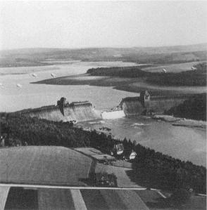
The Mohne dam in the aftermath of Operation Chastise.

As an élite precision attack force, 617 Squadron was used for special missions. After the Dambusters mission, it began to attract ridicule as ‘The Squadron with one op’. Barnes Wallis, however, came up with another revolutionary bomb, the 5.443 tonne (12,000 pound) Tallboy. The bomb was extremely aerodynamic, designed to be dropped from 18,000 feet (5,500 metres). That meant it hit the ground at 750 mph (1200 kph), which created a crater 30 metres wide and 24 metres deep. The idea was to produce an ‘earthquake’ effect so that if the target, such as a concrete bunker, was not itself smashed to pieces, it would just fall into the great big hole.

The Tallboy entered service on 8 June 1944 and was first used against the Saumur rail tunnel that night. The line was destroyed — one Tallboy drilled through the hillside and exploded in the tunnel about 18 metres below, completely blocking it. They were subsequently used against V-1 cruise and V-2 ballistic missile launch sites and facilities, and the V-3 supergun.

But Wallis’s background as a marine engineer resurfaced in September that year. Major surface combatants remained lethal adversaries, even though they were obsolescent in the face of submarine and air power. Throughout the war the German battleship the Tirpitz had evaded British attempts to destroy it, skulking in north Norwegian fjords. At 42,900 tonnes, she had been sister ship to the Bismarck. She remained a potential threat to the convoys supplying Russia, although by 1944 those were not as crucial as they had been. On 15 September1944 the ‘Dambusters’ Squadron launched Operation Paravane, attacking the monster from airfields in northern Russia under a special agreement with the Russian Allies, who obviously had an interest. At the time she was moored in the Kåfjord (Kaa fjord), south-west of the Altenfjord (Altafjord), at 69o 56’ 22” N, 23o 03’ 42” E. The Kåfjord was out of range of bases in Britain. Although Tirpitz was not sunk, she was crippled sufficiently to prevent her ever posing a threat again.

Prior to the actual raid, some 38 Lancaster bombers took off from RAF Lossiemouth in Scotland. Most were 617 Squadron but some were from 9 Squadron. One turned back and, after an eleven hour flight, the other 37 tried to land at Yagodnik airfield (64o 22 N, 40o 42 E) in north Russia, on the Northern Dvina river, close to Arkhangel’sk, which was designated as a temporary RAF base. Yagodnik was just 600 miles from the target. The base was drenched by heavy rain and thirteen of the British aircraft could not find the airfield and landed at various remote places across north Russia. Colonel Loginov, Chief of Staff of the White Sea flotilla, made determined efforts to find the aircraft and recover their crews, including one crew who were guided on foot to a lake where a sea-plane could pick them up and take them to the Yagodnik base. Two of 617’s aircraft and four of 9 Squadron could not be retrieved from the marshes where they had landed, but seven were recovered, plus, very importantly, all the crews. Without Loginov’s heroic efforts and those of his boss, Maj.-Gen. Dzymba, Chief of the White Sea Flotilla Naval Air Forces, the attack on the Tirpitz would have been much weaker. As a result the RAF later recommended Loginov, Dzymba and Vice-Admiral ‘Pantaleyev’ (Panteleyev), the Commander-in-Chief of the White Sea flotilla, for British honours. Panteleyev, as a Vice-Admiral, got the Companion of the Bath (CB), while Dzymba and Loginov were made Commanders of the British Empire (CBE).

Tirpitz

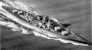
The German battleship Tirpitz at sea

Altenfjord

The Altenfjord

In the Kåfjord, surrounded by mountains and anti-aircraft batteries, Tirpitz was exceptionally well defended. There were also enough smoke diespensers to fill the fjord with a veil of smoke in just eight seconds. But One 12,000 lb Tallboy struck the ship 50 feet aft of her prow, pierced the bow compartments without detonating and came out under the waterline on the starboard side before exploding. This underwater explosion very close to her hull, plus those from other Tallboys exploding nearby did severe damage to her machinery and engines.
Though she remained floating, the Tirpitz was immobile and could only be repaired in a big dry dock, and it would be impossible to get her to one in Germany in the face of British naval and air superiority.
A German report recovered by the Allies after the war stated the Kriegsmarine’s conclusion: “It was eventually decided at a conference on 23 September 1944 at which the C-in-C – Admiral Dönitz – and Naval Staff were present, that it was no longer possible to make Tirpitz ready for sea and action again…” They tried to move her south to use as a floating battery for the defence of Tromso, but did not realise that this would bring her in range of bombers based in Scotland. The British did not know how badly they had damaged her and launched two more attacks. The first, Operation Obviate, inflicted no further major damage. But on 12 November 1944 the RAF launched a final attack, this time again beginning with a ‘C’, Operation Catechism. In a joint attack by 617 and IX Squadrons the Tallboy bombs hit her magazine, and she capsized with the loss of most of her crew.
Although Barnes Wallis is best known as an aero-engineer, who went on to develop the swing-wing concept used on the F-111 and Tornado, he began his long and creative career as a marine engineer. There was a certain irony in the use of his earthquake bombs to finish the Tirpitz. Like the underwater monster, the kraken, they wrested the great battleship from below, and pulled her beneath the deep…

Chris Bellamy

EU Maritime Day Public Seminar – People, Place and Fish: towards understanding the importance of inshore fishing to communities in the English Channel and southern North Sea

ABSTRACT
Fishing is important not just for economic livelihoods, but plays an important socio-cultural role in terms of heritage, sense of place, local identity and social cohesion. This presentation will report on work carried out in two EU Interreg funded projects GIFS (Geography of inshore fishing and sustainability) and CHARM III (Channel Integrated Approach for Marine Resource Management). In CHARM III sense of place was used as a framework to explore the cultural ecosystem services that marine fishing provides. In the GIFS project this work has been developed. Firstly, through a survey across fishing places in southern/eastern England, northern France, Belgium and the Netherlands, where people’s attachments to fishing places will be measured. Secondly, community, researcher and professional photography will be used to understand the diverse landscapes of fishing across the region and how these landscapes are shaping the practice of fishing and the character of those places. Alongside this sense of place research GIFS is now addressing numerous other ways that the importance of marine fishing can be felt in coastal communities. This presentation will include report on the role of women in fisheries and their contribution to the social cohesion of coastal communities focusing in particular on three countries: Belgium, England and the Netherlands.

Presented by Dr Tim Acott, Dr Julie Urquhart (School of Science) and Dr Minghua Zhao (Greenwich Maritime Institute), University of Greenwich

VENUE: Royal George Room (180), Queen Anne Court, University of Greenwich, Old Royal Naval College, Greenwich, London, SE10 9LS

TIME: 18:00

DATE: Monday 20th May 2013

There will be time for questions and answers and a drinks reception will follow.

FURTHER ENQUIRIES & BOOKINGS
Places are free but please book a place in advance by contacting:
Greenwich Maritime Institute, University of Greenwich
Email: (gmi@gre.ac.uk) Tel: 020 8331 7688

For more information about the London Universities Maritime Law and Policy Research Group please see our website: http://tinyurl.com/c73bs2w

The European Maritime Day is celebrated annually across Europe on 20 May.
It shows the importance of the sea and oceans for everyday life, both in coastal communities and in landlocked areas across Europe. It also highlights the opportunities and challenges currently facing maritime regions and sectors.

A Student Perspective: The Role of the UK Chamber of Shipping

Many shipping- and trade’s associations have been established in the United Kingdom since the nineteenth century. However, the UK Chamber of Shipping in its current form dates only from 1975. In 1878, most of the above mentioned associations agreed to support the formation of a national trade association, the Chamber of Shipping of the United Kingdom. This rapidly became the dominant trade association for shipping and most of the older, regional associations became members. The Chamber’s forerunner was granted a Royal Charter in 1921, and in 1975 merged with the Shipping Federation, which was formed as an employers’ association in response to increasing trade union activity in 1890. In 1992, the forerunner was renamed as the Chamber of Shipping and was re-branded as the UK Chamber of Shipping in 2012, to emphasize its identity.

The Chamber is recognized by the UK Government, EU institutions and other national and international organizations as the focal point for consultation with the British shipping industry on regulatory and other key developments, thus giving it advance notice of forthcoming changes. The Chamber has a well-developed mechanism and communication channels for promulgating relevant information throughout the industry, Government, Parliament, international organizations, unions, general public as well as media.

The mission of the Chamber is to champion and protect the UK shipping industry on behalf of its around 140 members from across the maritime sector, representing over 28 million DWT members. They are passionate about UK shipping and work to champion its future success and London’s status as the premier global maritime centre. The Chamber work closely with Government, Parliament, policy makers and other parties to:

1. Gain recognition of shipping’s contribution to the UK economy and employment;
2. Make clear the impact of upcoming and existing legislation on the future of shipping in the UK;
3. Bring them together to work with the UK shipping industry and the related national, European and international maritime organizations.

The UK Chamber of Shipping has five committees covering the most prominent policy areas for UK shipping within its membership and three sector panels to deal with issues affecting particular sections of the shipping industry. The Chamber is monitoring the new developments of shipping and other relating spheres, it proposes and agrees policy, it represents that policy to the appropriate audiences, aims at the adoption of its policies and at ensuring their implementation. The Chamber works with a range of national and international regulators, maritime and trade bodies across the industry, which often have common goals in terms of lobbying and political activity and championing the profile of maritime activities. The UK Chamber is often active within this cluster to help the UK maritime industry to achieve its common goals.

According to ‘The economic impact of the UK maritime services sector’ published by Maritime UK in December 2012, the maritime services sector made an estimated £13.8 billion direct value-added contribution to GDP in 2011, equivalent to 0.9% of the UK economy. It is estimated that the maritime services sector created approximately 262,700 jobs in 2011 or 0.8% of total UK employment. Moreover, including direct, indirect and induced impacts, the maritime services sector is estimated to support 634,900 jobs, or 1 in every 50 jobs in the UK. Moreover, once these multiplier effects are accounted for, the sector makes a value added contribution to GDP of £31.7 billion, equivalent to 2.1% of the UK economy. The above mentioned figures imply that the maritime industry is a larger employer, contributor and producer for UK national economy. And furthermore, these figures indicate that the role of the UK Chamber of Shipping is really important not only for the British shipping but for the whole British economy, now and in the future.

Hsien-Chang Yang, MA International Maritime Policy Student

A Student Perspective: Shipping Pools, Liner Conferences by another name?

Shipping Pools. Refer to them as you wish: the reincarnation of a bygone shipping system, shipping economic metamorphosis, old wine in a new bottle, the 3rd way shipping method – whichever way you want, the core facts remain unchanged. Shipping pools are the Liner Conference systems all over again, right?

For a century and half or thereabouts, shipping concerns were able to arrange themselves into cartels called conferences in a bid to agree, among other things:
• the quantity of goods that could be allowed on the market at any one time
• the schedules of deliveries
• the freight rates
• the terms of contracts
• the allotments of freight to be ferried by individual ship owners (quotas)

This easy, unchallenged way of making money continued even after the birth of the mother of all supra-national policymaking institutions, the EEC, the forerunner of the EU. These cartels were exempted from all European competition laws for many years as a way of protecting the European shipping industry – a kind of bulwark against flag of convenience shipping, a way of augmenting Europe’s lost competitive edge in the global market place – a way of ensuring greater prosperity in Europe. Can you believe it? Yes. Take it from me. It is true. Shameful but true, really.

However, everything came to an end when in the wake of immense pressure from the United States and GATT, the predecessor the World Trade Organization (WTO), it suddenly dawned on the Europeans that the conferencing business model was not only utterly uncompetitive but also hugely unfair to all non European shipping companies and all non European consumers, especially those in dirt poor developing countries. Hence, under EU guidance, the Liner Conference system was faced out slowly and finally prohibited on 17 October 2008. It was said then that a breach of the prohibition would result into hefty fines, anything up to and beyond a shipping company’s global one year profits.

Gee. How did the ending of the Conference impact European ship owners? How did it impact freight rates and surcharges worldwide? What about service levels – did they go up or down? It is reasonable to wonder if someone has ever incurred the wrath of the EU, right – and how much was the penalty? How did it impact regional port throughputs? What about impoverished states – how did the end of the Conference impact them? Be a good maritime student. Find out on your own. Every good admiralty and maritime law guide published after 2008 have answers to these questions.
Tell me. How are liner conferences different from shipping pools? Are they one and the same animal? What are shipping pools, anyway? Read my next piece to find the answers to these hot questions.

Gola Traub, MA International Maritime Policy Student

Too Many Ships in the World Merchant Fleet

For ship spotters and maritime historians, it was an event of great significance. Back in 2005 the world fleet of cargo-carrying ships reached the symbolic 50,000 number. Today there are many more, and their capacity has risen enormously. For shipowners and market analysts, this enlargement is also significant, but has worrying overtones: expansion in many categories has greatly exceeded the growth of seaborne trade and demand for these vessels. The result has been varying degrees of depressed shipping markets over much of the past few years.

The world merchant ship fleet is very large, probably larger than most people would guess. But just how many vessels are there? What is their cargo carrying capacity? How did this fleet develop in recent years and why? And what is the outlook for the future? The answers to these questions are of interest not only to those participating in, or merely observing, this remarkable industry; they are scrutinised intensely within academic maritime studies at GMI.

Fleet statistics weave a fascinating pattern. By mid-2011 the world’s entire fleet of all types of commercial ships over one hundred tons had increased its gross tonnage to 1 billion. At the end of last year the total reached 1.09 billion GT, numbering 86,300 ships. This gigantic armada includes not only the vast fleets of bulk carriers, tankers and container ships, but also a wide range of other types. General cargo vessels, multi-purpose ships, car carriers, roll on-roll off vessels, gas carriers, reefer tonnage, cruise ships, offshore service vessels and others (such as tugs and dredgers) are represented. Many perform services which do not involve carrying cargo, of course.

According to figures compiled by shipping information providers Clarksons, another (nautical) milestone was attained recently. The world’s fleet of vessels actually carrying cargo – which had numbered 50,000 over seven years ago – reached 1 billion GT in September last year, and since then has grown to 1.01 billion, comprising 57,400 ships, today. It is especially significant that this achievement resulted from cumulative growth of an astounding 43 percent over the past five years, averaging 7.5 percent annually.

Looking at the fleet statistics in more detail reveals some impressive performances over the past few years. Expansion rates in the largest sectors have been rapid. Measured by deadweight volume, the tonnage measurement normally used in the bulk markets, the world fleet of bulk carriers has grown by 73 percent in the past five years. At the end of 2012 there were 9,500 bulk carriers totalling 679 million dwt. The tanker fleet’s growth was 29 percent during the same period, to a total of 515 million dwt (13,500 ships, including 7,700 small tankers below 10,000 dwt). In the container ship sector, where the standard measurement is TEUs (twenty-foot-equivalent units), the world fleet reached 5,100 ships totalling 16.2 million TEU at the end of 2012, after growing by 50 percent over a five-year period.

Why is all this a problem? Unfortunately (for shipowners and their bankers), expansion of transportation capacity in the main fleet sectors has outpaced the growth of global seaborne trade and demand for shipping services. The market’s two sides are often out of balance, to some extent, but in the present cycle the imbalance (oversupply) is particularly large and persistent and is having a brutal impact on freight earnings and profitability.

Contrary to many perceptions, international cargo movements have been growing quite vigorously in recent years. There has been a good recovery from the damaging setback experienced in late 2008 and 2009, when the global financial crisis caused the ‘Great Recession’, which severely but temporarily reduced world economic activity and trade volumes. The upwards trend in seaborne trade resumed and continues, with most forecasts suggesting further strengthening through 2013. A positive trade scene is therefore evolving; some other factors which affect shipping demand have been beneficial as well. On the other side of the balance sheet, enormous amounts of new shipping capacity coming in to the marketplace (partly offset by higher scrapping) has greatly swelled the fleet, as discussed. Much of this new tonnage, or ‘newbuildings’, was ordered at shipbuilding yards in better times when the shipping markets were booming. The result – more rapid fleet expansion than needed – is still unfolding and signs suggest it will continue.

Where do we go from here? Forecasters in this notoriously hard-to-predict industry are frequently wrong-footed by unanticipated events. If the world economy soon takes off again and stays there, boosting trade, surplus shipping capacity could be quickly eliminated, but few expect that to happen. Although China’s economic growth appears to be reviving, the USA is picking up, and Japan could start regaining momentum, Europe’s economy is still in the doldrums and probably will remain there for a while. Political events could disrupt trading patterns and potentially add to demand for ships, but these circumstances are essentially unpredictable. There are other factors, of course, but no indications at present of a quick solution to the fleet over-capacity problem. The scale of the problem, although diminishing, is still so large that adjustment towards a better balance may yet take some time to complete.

Richard Scott
GMI visiting lecturer and MD, Bulk Shipping Analysis

GMI One-Day Short Courses: Maritime Crime; Maritime Ancestry and Maritime China

Greenwich Maritime Institute are delighted to announce that registration is now open for three one-day short courses that are to be held in June 2013.

The courses all reflect the expertise and interests of our teaching staff so are a mixture of historical and contemporary themes. Anyone is welcome to attend, there are no entry requirements.

Fees: Each one-day course costs £90 per person. However if you would like to attend more than one course the fee for two courses is £160, or for all three courses £240. Fees include course materials; certificate of attendance; lunch and refreshments throughout the day.

For a booking form and more details on the courses, please visit our website: http://www2.gre.ac.uk/about/schools/gmi/study/short/programmes


Public Seminar – European Diplomatic Shifts and the Development of Plymouth Naval Base 1717-1730

The next public research seminar of the 2012-13 programme will be taking place on Wednesday 20th February 2013 and will be presented by our very own, Dr Chris Ware.

Abstract: Between 1715 and 1727 Britain sent nine substantial squadrons to the Baltic to safeguard its interests. However, as the situation in the north of Europe began to settle, distrust began to increase again between Britain and Spain over Gibraltar and trade in the West Indies. Fighting at Gibraltar in 1727 led to an extended period of tension. In 1732 for instance, Spanish military preparations resulted in British fears of a Jacobite invasion. This talk traces the development of Plymouth naval base against this diplomatic background, not only of the dockyard, but of the victualling and ordnance yards and the naval hospital. There was significant and continuous investment throughout these years, often regarded as a period of quiescence. Plymouth was not only a ‘fully-fledged’ dockyard by the beginning of the 1739-48 war, but also a significant naval base.

Location: Edinburgh Room (075), Queen Anne Court, University of Greenwich, Old Royal Naval College, Greenwich, London, SE10 9LS

Time: The seminar will begin at 6pm with refreshments available from 5.30pm

Anyone is welcome to attend this free event and no booking is required. If you would like any further information however please telephone the GMI Office on 020 8331 7688 or email gmi@gre.ac.uk.

Plymouth Image