The art of teaching war- have you booked your place???


July 22nd 6pm with wine reception Chris Bellamy

At The Old Royal Naval College, Greenwich 

booking email: l.hattersley@gre.ac.uk 

How do you force someone to fight for you – to go to war? This and other questions will be addressed at a free public lecture by a military expert and University of Greenwich academic.

Professor Chris Bellamy is Director of the university’s Greenwich Maritime Institute, in the Faculty of Architecture, Construction & Humanities. An award-winning author and former defence correspondent at The Independent, Chris is also an expert on Russia and the former Soviet Union. His views have been widely sought by media over the current tensions between Russia and Ukraine.

Don’t try this at home…: Teaching War, 400 BC to the present takes place at the university’s Greenwich Campus on Tuesday 22 July 2014 at 6pm.

Chris says: “Warfare – the use of violence for political ends – is as old as recorded history and, some would argue, is the ‘dark side of civilisation’. Warfare requires communities organised on some scale and a measure of authority to force people to participate in an exhausting, terrifying, arduous and often tedious activity which runs against many of our natural instincts.

“From the beginnings of recorded civilisation the communities most successful in armed conflict triumphed through better organisation, equipment, training, tactics, and the conceptual component – an intellectual understanding of the nature and processes of warfare. To win in battle, and in warfare more generally, training and education are key.”

Technology, technique and science all feature strongly in the history of war. Examples developed and explored by Chris during his 13 years as a teacher at the Defence Academy of the UK at Shrivenham reveal that, until relatively recently, one combatant seldom had a decisive technological edge over another. It was discipline, training and technique– how they used it – that determined success.

Chris has taught these ideas to students, including many serving members of the armed forces, for many years. He will present a number of case studies, including analysis of the leap from mechanical energy – bows and arrows and catapults, to chemical energy – guns and rockets. Chris will also discuss the importance of indirect fire – artillery firing at targets which those manning the guns cannot see.

Without this development in technique the First World War, the start of which is being commemorated this year, could not have happened as it did. Yet very few historians understand what indirect fire is, or mention its decisive role in shaping the fighting on land, particularly on the Western front.

Don’t try this at home…: Teaching War, 400 BC to the present. University of Greenwich Maritime Institute, presented with the Centre for the Study of Play and Recreation. Tuesday 22 July 2014, 6pm until 7.30 pm. Room 080, Queen Anne Court, University of Greenwich, Old Royal Naval College, SE10, 9LS. To be followed by a wine reception.

All are welcome to this free lecture but to book a place for the wine reception, please contact the Greenwich Maritime Institute on l.hattersley@gre.ac.uk

This lecture precedes the 36th Annual Conference of the International Standing Committee for the History of Education, Education, War and Peace, to be held at the Institute of Education, University of London, 23–26 July 2014.

Mary Clare Martin, Ewa Sidorenko and Leticia Fernandez-Fontecha Rumeu, of the Department of Education and Community Studies, will be speaking on a panel at the ISCHE conference, entitled Survival, Pain and Memory: recovering experiences of war, peace and education in Spain, Poland, Gibraltar and Britain, 1902-1950.


The art of teaching war – public lecture at the University of Greenwich

Chris Bellamy

How do you force someone to fight for you – to go to war? This and other questions will be addressed at a free public lecture by a military expert and University of Greenwich academic.

Professor Chris Bellamy is Director of the university’s Greenwich Maritime Institute, in the Faculty of Architecture, Construction & Humanities. An award-winning author and former defence correspondent at The Independent, Chris is also an expert on Russia and the former Soviet Union. His views have been widely sought by media over the current tensions between Russia and Ukraine.

Don’t try this at home…: Teaching War, 400 BC to the present takes place at the university’s Greenwich Campus on Tuesday 22 July 2014 at 6pm.

Chris says: “Warfare – the use of violence for political ends – is as old as recorded history and, some would argue, is the ‘dark side of civilisation’. Warfare requires communities organised on some scale and a measure of authority to force people to participate in an exhausting, terrifying, arduous and often tedious activity which runs against many of our natural instincts.

“From the beginnings of recorded civilisation the communities most successful in armed conflict triumphed through better organisation, equipment, training, tactics, and the conceptual component – an intellectual understanding of the nature and processes of warfare. To win in battle, and in warfare more generally, training and education are key.”

Technology, technique and science all feature strongly in the history of war. Examples developed and explored by Chris during his 13 years as a teacher at the Defence Academy of the UK at Shrivenham reveal that, until relatively recently, one combatant seldom had a decisive technological edge over another. It was discipline, training and technique– how they used it – that determined success.

Chris has taught these ideas to students, including many serving members of the armed forces, for many years. He will present a number of case studies, including analysis of the leap from mechanical energy – bows and arrows and catapults, to chemical energy – guns and rockets. Chris will also discuss the importance of indirect fire – artillery firing at targets which those manning the guns cannot see.

Without this development in technique the First World War, the start of which is being commemorated this year, could not have happened as it did. Yet very few historians understand what indirect fire is, or mention its decisive role in shaping the fighting on land, particularly on the Western front.

Don’t try this at home…: Teaching War, 400 BC to the present. University of Greenwich Maritime Institute, presented with the Centre for the Study of Play and Recreation. Tuesday 22 July 2014, 6pm until 7.30 pm. Room 080, Queen Anne Court, University of Greenwich, Old Royal Naval College, SE10, 9LS. To be followed by a wine reception.

All are welcome to this free lecture but to book a place for the wine reception, please contact the Greenwich Maritime Institute on gmi@gre.ac.uk.

This lecture precedes the 36th Annual Conference of the International Standing Committee for the History of Education, Education, War and Peace, to be held at the Institute of Education, University of London, 23–26 July 2014.

Mary Clare Martin, Ewa Sidorenko and Leticia Fernandez-Fontecha Rumeu, of the Department of Education and Community Studies, will be speaking on a panel at the ISCHE conference, entitled Survival, Pain and Memory: recovering experiences of war, peace and education in Spain, Poland, Gibraltar and Britain, 1902-1950.

Veteran Scottish steamer recces vast new London Gateway port and deftly dodges 1.5 kilotons of High Explosive

On Sunday 29 September some of GMI’s staff and alumni  took the opportunity to explore the River Thames from the City to Southend and the mouth of the River Medway, including a unique close reconnaissance of the new London Gateway port which is due to open in November 2013, aboard the Glasgow-based steamer Waverley.

Waverley, completed in 1947,  spends her summers cruising on the Firth of Clyde into areas of spectacular natural beauty. She also spends spring and autumn sailing in other areas including  south-west England (Dorset and Devon),  the Bristol Channel, the south coast of England and the Thames estuary.  Since 1974 she has been owned by a registered charity (Waverley Steam Navigation Company) on behalf of the Paddle Steamer Preservation Society (PSPS), itself a charity, and operated by Waverley Excursions Ltd, a subsidiary of WSN. She is described as the ‘World’s last Sea-Going Paddle Steamer’, and sometimes cruises out of protected estuarine waters and across more open seas, including up the east coast to Harwich, Ipswich, Great Yarmouth and Southwold. She sailed across the Channel to commemorate the sinking of her predecessor, built in 1899, during the 1940  Dunkirk evacuation.  Being a paddle steamer she is extremely stable, but she only has one giant engine, which means she cannot turn very tightly by contra-rotating the paddles.  But she is manoeuvrable enough, even for the relatively constricted waters of the Pool of London.

The Paddle Steamer (PS) Waverley
http://www.google.co.uk/imgres?imgurl=http://4.bp.blogspot.com/-

And the engine is open for all to see, her immaculate, slightly greased metallic silver connecting rods, carrying the energy from the pistons, pumping rhythmically to turn the crankshaft in a stimulating display of raw power.

On that special Sunday she left Tower pier at 10.00 hrs sharp with about 200 passengers aboard.  She sailed west, towards London Bridge, swung round above the site of the old Roman  bridge, and headed out under Tower Bridge which opened for her. The Waverley cruise has become something of a GMI tradition over the last five years, but the prospect of a close encounter the new mega-port on the verge of completion made this year’s excursion particularly timely.  Aboard were Chris Bellamy, on his first Waverley trip accompanied by Jos McDiarmid, a friend specialising in antique prints and a qualified London tour guide, the usual suspect Dr David Hilling, a world expert on ports, Richard Scott, and graduates and continuing students from the Maritime History MA including John Allan,  John Mann and his son, Robert Milburn, Tim Carter, his partner Anne and friend, and Peter Jarrett, plus a representative of the new Maritime Security MSc, Leo Balk, who is a former Commander in the US Navy.

The weather was overcast and quite stormy, and on the wider river there was a strong wind which made using maps challenging, but blew any cobwebs away. After Tower Bridge, Brunel’s Thames Tunnel and Canary Wharf, Greenwich came into view.

Member of general public points out world-famous GMI offices

Soon afterwards there was a good view of the Emirates AirLine cable car, which is a spectacular sight but might be more useful if it went somewhere, either to the

Excel Exhibition Centre, further east,  or directly to London City Airport.  But maybe that was just a ‘bridge’ too far.

‘Sail on, silver girl’.  Waverley passes under a bridge over troubled waters…
‘Sail on, silver girl’. Waverley passes under a bridge over troubled waters…

Then came the Thames Barrier, designed to defend the Capital against the power of the sea.  One of the barriers was obligingly raised in ‘defensive’  mode.  The Thames  Barrier,  which has been operational since 1982, has a finite life, and will need to be replaced at some point, but a March 2009 study suggested that it  would last decades longer than the date of 2030 when its designers thought it would have to be replaced. In part, this was because they had apparently overestimated the effects of climate change.  The barrier was designed with an allowance for sea level rise of 8mm per year until 2030, which has not been realised in the intervening years.  The Environment Agency have no plans to replace it before 2070 and a decision on its replacement, which might be further downstream, therefore needs to be made in the middle of the century.

Thames Barrier with one of the  flood gates raised in ‘defensive’ mode
Thames Barrier with one of the flood gates raised in ‘defensive’ mode

The route so far can be traced on the Google Earth photo, below. The next part of the trip was more revealing.  The Thames Barrier is not the only London flood defence by any means.  Two kilometres from the eastern end of London City Airport, ad Ordnance Survey grid 456817, on the left of the river (to Port), we saw the imposing and intimidating outline of the Barking Creek barrier, which can be dropped as a giant guillotine to seal Barking Creek against the same tidal surges from the North Sea that the Thames Barrier is designed to thwart.

First part of Waverley’s journey, 10.00-11.00 hrs. Google Earth, adapted and annotated by author
First part of Waverley’s journey, 10.00-11.00 hrs.
Google Earth, adapted and annotated by author
The Barking Creek Barrier (north side of the river Thames)

And then, further on, on the ‘right bank’ of the river (always seen from the direction of flow, remember…), the Dartford Creek (River Darent) tidal barrier. OS grid 541778:

Dartford (River Darent) Tidal Barrier (south side of the river Thames)

Four kilometres beyond this point the Waverley passed under the Queen Elizabeth II (QEII) bridge, which carries the southbound carriageway of the M25 orbital road southward.  The northbound carriageway passes through the Dartford tunnel a little before. The central point of the bridge is at OS grid 570764.

The best shot of the bridge is probably taken from further east, as shown below.  The traffic is therefore passing southward, to the left, with the south bank on the left and the north on the right of the picture.  The overall position of the bridge can be seen in the adapted Google Earth view, which follows.


QEII Bridge, seen from the east, with the south bank on the left,  Traffic passing from right to left.
QEII Bridge, seen from the east, with the south bank on the left, Traffic passing from right to left.
View of the QEII Bridge and the approaches to Tilbury. Google Earth, adapted and annotated by author
View of the QEII Bridge and the approaches to Tilbury.
Google Earth, adapted and annotated by author

After Tilbury docks, Waverley passed Tilbury Fort, skulking behind its earthworks, and very difficiult to see (OS grid .  After the Dutch raided the Medway in 1667, King Charles II ordered a fort built here to defend London.  It was designed  on the latest lines, following the schemes of the great French military Engineer Sebastian le Prestre de Vauban.  It was built by a Dutchman, Sir Bernard de Gomme, and its fearful pentagonal geometry incororated the latest ideas in 17th century fortification.  Originally the fort, designed to withstand a serious assult from the landward side, was combined with batteries along the northern shore of the river, as shown in the artist’s impression of it in the eighteenth century, below.

Tilbury  Fort as it would have looked in the 18th century (Alan Sorrell) http://www.englishheritageprints.com/tilbury_fort_j910014/print/674682.html
Tilbury Fort as it would have looked in the 18th century (Alan Sorrell)
http://www.englishheritageprints.com/tilbury_fort_j910014/print/674682.html
Tilbury Fort today, with the high tide filling the moat http://www.google.co.uk/imgres?imgurl=http://www.english-heritage.org.uk/content/images/property-defaultimage/tibury_fort_lead_image.
Tilbury Fort today, with the high tide filling the moat
http://www.google.co.uk/imgres?imgurl=http://www.english-heritage.org.uk/content/images/property-defaultimage/tibury_fort_lead_image.

Beyond Tilbury Fort we rounded the bend in the river, heading north again into Lower Hope Reach.  The new Thames Gateway port, buyilt on the site of the former oil refinery at Shellhaven, which closed in 1999, came into view. As you can see from the air view, the new  port is vast.  Its shape is quite distinctive, and it is easy to reconcile the artist’s impression of the completed port with the air view.

London Gateway. Google Earth, adapted and annotated by author
London Gateway.
Google Earth, adapted and annotated by author
Approaching London gateway from the west.

The Waverley moved close in to the north bank to give us a good view.  As we slipped past huge excavations were still underway. The technique used to construct the quay wall which will also support the tracks which carry the huge cranes is not  new but has not been much used in the UK previously. The shoreline was build out extensively, so that the quay wall could be installed below ‘dry land’ The fill behind the quay wall then becomes the fill under the quayside areas.

The start (west end) of the London Gateway  quay wall
The start (west end) of the London Gateway quay wall

The two lines of quay wall also double as the support for the enormous quayside container cranes so the capping beams have the necessary rails and infrastructure cast into them. Once the quay wall, anchor wall and tie bars are complete, the fill in front of the quay wall is dredged out leaving the quayside complete.  The cranes run on tracks that are 35 metres (115 feet!) apart, giving an idea of their enormous size.  The first phase of the quayside wall in 1,250 metres long.

First, fill it in… http://www.google.co.uk/imgres?imgurl=http://constructionetc.files.wordpress.com/2011/07/quay-wall.jpg&imgrefurl=http://constructionetc.wordpress.com/2011/07/24/ice-essex-works-visit-london-gateway-port/&h=675&w=919&sz=59&tbnid=twKnRANsYhVwPM:&tbnh=124&tbnw=169&zoom=1&usg=__qVlbW1yIHBmhzycpr8zFUXJSvN8=&docid=JjFnTdjdYGr4yM&sa=X&ei=32NVUomBC6K-0QXY0YCADw&ved=0CDEQ9QEwAQ
First, fill it in…
http://www.google.co.uk/imgres?imgurl=http://constructionetc.files.wordpress.com/2011/  
Then, dig it out… As above, adapted by author.
Then, dig it out…
As above, adapted by author.

One ship was already moored at the port, although it does not formally open until November. And two weeks before, on 16 September, it was reported that THE 10,062-TEU Zim Rotterdam, had diverted from Felixstowe to DP World’s London Gateway port for repairs after a fire aboard had consumed 20 containers. Industry sources said Felixstowe would not accept Zim Rotterdam because the vessel would tie up berthing space for a prolonged period, but Felixstowe officials were not available for comment. Instead, it was offered a haven at  London Gateway, which will not open until later this year.  As a result of an unplanned delay, London Gateway port agreed to accommodate the vessel at short notice. Three weeks before, ago, the master had reported a fire in 20 of its containers while en route from Malaysia to Djibouti.  The AIS vessel monitoring system showed that Zim Rotterdam was located off Cherbourg when the new London Gateway destination was determined.

As we passed the new mega-port the size of the cranes on their 35-metre wide track could easily be appreciated.

London Gateway, 29 September 2013

London Gateway comprises a large new deep-water port, which will be able to handle the biggest container ships, as well as one of Europe’s largest logistics parks, providing effective access (by road and railways) to London and the rest of mainland UK.  The complex will make use of modern technology to increase productivity and reduce costs for shipping lines and the logistics industries. It will significantly increase the ability of the Port of London   to handle modern container shipping, and help meet the growing demand for container handling at Britain’s ports.

The Red Ensign flies over London Gateway, which will make the Port of London a world-leading terminal for container shipping

DP World, a Dubai-based company,  received Government approval in May 2007 for the development of London Gateway. The proposals were identified by former prime Minister Gordon Brown  as one of the four economic hubs essential for the regeneration of the Thames Gateway.  The 2007-10 financial crisis created problems for DP World’s owners Dubai World.   However, in January 2010, DP World was given the go-ahead for construction of the port

London Gateway port will include a 2,700-metre-long container quay, with a fully developed capacity of 3.5 million TEU a year.  It is close to  the major shipping lanes serving north west Europe and will increase national deep-sea port capacity for the UK.  At present, the ports of Felixstowe and Southampton are  the first- and second-largest ports by container traffic in the UK, respectively, with the Port of London third.  There are a number of other smaller container terminals nearby, but the development will dramatically increase the capabilities of the Port of London in handling modern container shipping.    DP World has said that high-quality architecture, sustainability, and high levels of security and management will be key features of the park and will create an attractive environment for occupiers

DP World is planning to invest over £1.5bn to develop the project over a ten to 15-  year development period. It says (well, it would, wouldn’t it?) that London Gateway will deliver about 12,000 new direct jobs, benefit the local and regional economy, and assist the government’s regeneration initiative. In addition, there will be over 30,000 indirect and induced jobs.

Our intelligence mission complete, and by this time very windblown, we repaired below.  The Waverley served an excellent Sunday roast, and  the stability of the ship was noticeable as  she ploughed through a very choppy Thames Estuary towards Southend.  Some of the passengers disembarked there, but the Captain warned that he could not guarantee to get back at 17.00 hrs to pick them up.  At sea, no plan always survives contact with the elements.  We then headed  south, into the estuary of the Medway.

Google Earth, adapted and annotated by the author

I was still below when we passed by the wreck of the Richard Montgomery,  a US Liberty ship that had gone down in 1944 with several thousand tonnes of ordnance on board. On 20 August 1944, it dragged anchor and ran aground on a sandbank around 250 metres from the Medway approach Channel, in a depth of 24 feet (7.3 m) of water. Liberty ships of this type – ‘general dry cargo’ –  had an average draught of 28 ft (8.5 m).  However,  the Montgomery was trimmed to a draught of 31 ft (9.4 m). As the tide went down, the ship broke its back on sand banks near the Isle of Sheppey 1.5 miles (2.5 km) from Sheerness and 5 miles (8 km) from Southend. The salvage operation  began on 23 August 1944, using the ship’s own cargo handling equipment. But the next day the ship’s hull had cracked open, causing the bow end to flood. Attemp[ts to salvage the lethal cargo continued until 25 September, when the ship was finally abandoned. Subsequently, the ship broke into two separate parts, roughly in the middle.  Some 1500 ‘short tons’ (the standard US measure for weight of  ordnance), or 1400 tonnes, were left on board.

The Richard Montgomery is a potential hazard to developments in the Thames Estuary.  The map below shows the position of the wreck vis-à-vis some planned developments – the various estuary airports beloved of, among others, London Mayor Boris Johnson.

Map showing position of the Richard Montgomery wreck and suggested airport developments:  1. Cliffe; 2. Grain (Thames Hub); 3. Foulness; 4. Off the Isle of Sheppey; 5. Shivering Sands (‘Boris Island’).
Map showing position of the Richard Montgomery wreck and suggested airport developments: 1. Cliffe; 2. Grain (Thames Hub); 3. Foulness; 4. Off the Isle of Sheppey; 5. Shivering Sands (‘Boris Island’).

In 1970 the BBC reported that the 1500 short tons – 1.5 kilotons – of explosives could, if detonated produce a 3,000-metre high column of water and a five metre tidal wave that would engulf Sheerness (population then 20,000).  By 2012 estimates of its possible effect were less sensational, but a one metre tidal wave might still result.  However, in 1998 The Maritime and Coastguard Agency (MCA) had said that as the fuzes would probably have been flooded for many years and the sensitive compounds were all soluble in water,‘ this is no longer considered to be a significant hazard.’

At least the wreck is clearly visible.  Given the weather conditions, Waverley did not pass very far down the Medway, just past the Swale, the stretch of water which separates the Isle of Sheppey from the mainland.  She got as s far as  Saltpan reach, south of the jetties and power station in OS grid square  8674, before turning round.

On the way back the Waverley passed east of the wreck site, before turning west.  The Richard Montgomery’s three masts are clearly visible.

Passing the Richard Montgomery, with Southend visible behind

The light was now beginning to fade and we repaired below for a while longer.  The Waverley did make it back to Southend, picked up some passengers, and then  headed back into London.  As darkness fell around 19.00 we headed back on deck and  the lights came on.  The imaginative use of lighting can utterly transform a landscape.  The Thames Barrier and to O2 were cleverly illuminated.  Beyond the O2, from the Royal Observatory, the Greenwich Meridian, the centre of the world, dividing east from west, was marked by a green laser pointing slightly upwards into the sky.  Unfortunately it would have needed a long exposure to capture this beam of light, and I missed the shot.  But an idea of the effects can be obtained from the kaleidoscope of colour bathing the O2, below.

O2, or alien spacecraft?

The Waverley passed on, under Tower Bridge, and docked at 20.45.  It was a great day, and a marvellous opportunity to behold  London’s new great port.

I could not help wondering what would really happen if what remained of the Richard Montgomery’s cargo were detonated all in one go.  I am sure that Maybe a future Mayor of London, inaugurating an estuarine airport, might have the opportunity to find out.  Mind you, I am puzzled by the need to build vast concrete runways.  Why do we not go back to sea planes and flying boats, which could land and take off in this vast area with far less infrastructure investment.  And bring back more civilised travel into the bargain. But a future Mayor might still want to press the button, just for fun.

Hey!  That gives me an idea…

Chris Bellamy


Unless otherwise stated, all photographs by the author.


One-Day Courses: Maritime Business in China; Maritime Crime; Maritime Genealogy

Three Course Leaflet

Maritime Crime: Piracy, Smuggling, Wrecking and Watery Whodunnits (A one-day short course)

banner

The Greenwich Maritime Institute invites you to dive into a dark whirlpool of wrongdoing, past and present. Piracy, committed for private gain, is a form of maritime crime often in the headlines, but it is far from the only one. Led by Professor of Maritime Security Chris Bellamy, Dr Cathryn Pearce, author on wrecking, and Dr Helen Doe from Exeter University, an authority on smuggling, you will navigate through the depths of mankind’s misdeeds on the high seas, rivers and ashore.

The course will explore four main types of sea crime: piracy; wrecking; smuggling; and the wide variety of crimes committed aboard cruise ships, merchant ships and luxury yachts. Among the issues covered will be:

  • What is maritime crime?
  • Piracy then and now
  • Wrecking then and now
  • Smuggling then and now
  • Maritime murder

The course will take place on Wednesday 12th June 2012 from 9.30am – 4.30pm. The cost is £90 per person which includes lunch, refreshments, course materials and a certificate of attendance. A booking form can be found on the Greenwich Maritime Institute website: http://www2.gre.ac.uk/about/schools/gmi/study/short/programmes

Wreck image 250 pixels

Not Chatham House Rules!

On Friday 10 June HMS Illustrious, the second of the Royal Navy’s three Invincible class light aircraft/helicopter carriers, was moored just upriver from GMI. At 22,000 tons, and at 209 metres long, she is a big ship – but just half the size of the Prince of Wales and Queen Elizabeth that will replace her – eventually. Initially conceived as a Harrier-carrier, and able to carry 22 of the Short-Take-Off-Vertical-Landing (STOVL) planes, she has been both a light aircraft carrier, in that role, and a helicopter carrier, able to carry 22 helicopters. There could be no more appropriate place to hold a conference to mark the 70th anniversary of the turning point in the Battle of the Atlantic, which took place in May 1943.

The Battle of the Atlantic, which lasted from 1939-1945 was probably the most crucial part of the Second World War for the UK’s survival and the subsequent liberation of western Europe. It lasted, from 1939-1945, when the last German submarines surrendered at (London) Derry, in Northern Ireland. The ‘Battle of the Atlantic Anniversary Seminar’, organised by the Royal Institute of International affairs, Chatham House, took as its theme, appropriately enough, ‘The Navy’s Role in resilience and Prosperity’. Unusually, the famous ‘Chatham House rule’ – that information gleaned might be used but not attributed to Chatham House, the speaker or the occasion, was waived. This one was on the record. So you can cite this blog!

When Royal Navy ships put it in to port for supplies, the purser and his or her team scour the hinterland for the best provisions, and London had been no exception. The Navy cooks – always superb – had produced the most impressive lunch, including truly spectacular dressed crab. With the new Billingsgate fish market just two kilometres away, at Trafalgar Way, West India Docks, Isle of Dogs, that would have been a no-brainer!

HMS Illustrious at Greenwich, 9-13 May 2013

After a welcome by Commodore Neil Brown of the Naval Staff, and Commander Keri Harris, the Second-in-Command, Professor Andrew Lambert from King’s College London opened proceedings with an account of the momentous conflict, and some interesting comparisons with now. The United Kingdom had not been self-sufficient in food production – never mind luxuries like tea and wine – since the 1780s. By 1939 the United Kingdom needed one million tons of provisions a month imported by sea.  In contrast, the United States was – and still is – self sufficient.  But, Professor Lambert noted, even at the worst moment of the Battle of the Atlantic there were more reserves of food and fuel in the UK than there are now, with our ‘just-in-time’ economy! 

A key point, reinforced in the questioning, was that the Royal Navy had responded well to the experience of World War I and the battle with the U-boats, including, for example,  the development of sonar.  But the plan was to contain German U-boats in the North Sea – which the Navy succeeded in doing until the fall of France in May 1940.  As Professor Lambert  laconically observed ‘you don’t plan for your Allies to collapse’. Good point.  After May 1940 the U-boats could operate out of French ports and far into the Atlantic (including off the coast of the United States). With U-boats loose in the Atlantic convoys bringing Lend-Lease and other  supplies from North America became targets. The stakes were suddenly raised. 

However, another crucial and countervailing development in 1940 was the German invasion of Norway.  Again, it is not widely known, but as a result most of the Norwegian merchant fleet headed for the UK, and became available as part of its merchant navy.  It took two years for the Germans to sink an equivalent number of ships.

By May 1941, however, the Germans believed the convoy system was cracking under the strain and sent the powerful surface raider the battleship (BB) Bismarck out to finish the convoys off. The sinking of the Bismarck was one crucial point in the battle.  The entry of the United States into the war in December 1941 further changed the dynamic.  The United States and Canada were no longer just supplying the UK. From then on, in operation Bolero, they were turning the UK into the jumping-off point for the invasion of north-west Europe.

Professor Lambert identified the Russian arctic convoys as the Royal Navy’s greatest ever success.  Those supplies got through in the face of a surface, submarine and air threat and the appalling weather. 

During the Battle of the Atlantic 783 U-boats were destroyed.  Laconically, again, Professor Lambert concluded,  ’75 percent fatal casualties was the German U-boat breaking point’. It was a  tough business.

Another Lambert, Dr Nicholas, from the Royal United Services Institute picked up the theme of the UK’s dependence on the sea. In 1914 the world economy was as ‘globalised’ as now, as a result of several revolutions.  In addition to the introduction of steam ships, there had been the introduction of undersea and trans-oceanic cables, permitting instant communication, and a revolution in financial services with credit easy to obtain and manage.  The UK’s national debt in 1914 was £650 million, a huge sum for the time. This global, interconnected system was rudely shocked by the First World War. Between 1914 and 1939, with the financial crises of 1929 and 1931, the world economy actually shrank.  As a result it was easier to keep it working in 1939. By 1940-41, some 55 percent of the UK’s GDP was devoted to war production, a figure never exceeded anywhere else, apart from the Soviet Union later in the war.  There was a draconian system of price controls, labour controls and rationing.  By 1941 the UK had exhausted its overseas credit.  Everything was sacrificed to win the war, without thought for the future.  The Atlantic became a pipeline along which war materiel was pumped from the US and Canada to the UK.  Yet, paradoxically, the UK’s vulnerability to disruption of its imports and supplies is greater now than it was in 1914.

After an excellent presentation by Dr Douglas Guilfoyle of University College, London, on modern challenges and the Law of the Sea, the seminar then addressed they key modern issues of the role of navies in resilience and the role of navies in prosperity. Rob Bailey from Chatham Hose explained the role of the oceans in food security, explaining that although we tend to think of the key chokepoints in terms of energy security – the Bosphorus, Suez Canal, Bab-el-Mandeb and Strait of Hormuz – they are just as vital for shipments of grain, which does not grow well in the Middle East. As a historical not, we might also recall that some 400,000 people died of malnutrition in Germany in 1914-18 as a result of the Allied blockade. In 2008-09 30-40 percent of Somali food requirements were met by UN food aid, so Somali piracy, which forced cessation of these shipments hit Somalia very badly.

Adjoa Anyimadu of the Africa Programme at Chatham House  addressed the naval response to piracy and the lessons to be learned from the Indian Ocean. She began by summarising the international presence, with three forces:  the EUNAVFOR and Operation Atalanta; the US-led Combined Task Force (CTF) 151 and Nato’s Operation Ocean Shield. To this we should add the one-nation contributions of China, Russia and Japan. She cited Oceans Beyond Piracy’s estimate that in 2012 Naval operations in the Indian Ocean cost more than £1 billion. Given that Somalia is a failed state, international naval action is legitimate.  The situation in west Africa and the Gulf of Guinea, where, in contrast to the Indian Ocean, piracy is on the increase, is quite different.  Here, there are Governments with authority over their territories and some rule of law. Therefore, a similar type and scale of Naval operations is unlikely.  However, there are still lessons to be drawn from the Indian Ocean. These are:

  • Capacity building – helping the local authorities to help themselves –  is crucial.  This not only applies to building coastguard and marine policy forces but the helping the shore authorities as well;
  • Intelligence gathering and information sharing is vital, including the use of new technology such as Unmanned Air Vehicles (UAVs), helicopter cameras and so on.  This is not only useful for providing advance warning but also to assist prosecution later on;
  • Conducting multinational operations helps develop relationships between navies and nations;
  • Navies must engage with the coastal communities whence piracy and armed robbery at sea emanate. In Somalia this has taken time but encouraging the coastal communities to see themselves as stakeholders who will benefit from seeing an end to piracy has worked.  In one case, international forces have intervened to provide medical treatment for sick Somalis on board ships.  Although this was regarded as possibly too dangerous, it worked. 

Bob Dewar, also of the Chatham House Africa programme, then addressed the key issue of IUU (Illegal, Unreported and Unregulated)(the Us in that order, OK?) fishing .  He began by citing Kofi Annan, that ‘human security’ was ‘not purely military’, in terms of political violence, but also embraced health, food, the environment, human rights and the rule of law.

IUU fishing is the worst maritime threat that west Africa faces, costing that part of the world an estimated $1 billion  (as against between $9 bn and $22 bn worldwide). In West Africa, however, fish resources are really important.  The UK MoD has set up a centre in Nigeria to support the ECOWAS (Economic Community of West African States) Maritime Strategy, and countering IUU fishing plays an important part of this.  It is not just the value of the fish, but also the lost revenue from licence fees and landing fees. 

Alex Vines OBE, the Head of the Africa Programme at Chatham House added to the unwelcoming picture of the Gulf of Guinea, pointing out that in addition to IUU fishing, other maritime crime accounted for another $1 billion.  Nigeria, Benin and the surrounding area are in the same insurance category as Somalia.

Douglas McWilliams, Chief Executive and Professor of Commerce at Gresham College, gave the final keynote speech. His World Economic League Table forecasts were fascinating. In 2012, the US was still the world’s largest economy, with China second,  Japan third, Germany fourth, France fifth and UK sixth.  In 2022 the top three will remain the same, with India fourth and Brazil fifth, Germany sixth, Russia seventh, UK eighth and France ninth.  But China will overtake the US in about 2025, as many have predicted. The prospect for the UK was surprisingly optimistic.  Consumer spending currently accounts for 70 percent of the UK economy and exports 30 percent.  By 2022, his group’s forecast indicates, consumer spending will have dropped to 50 percent and exports risen correspondingly. Eric Grove, from Salford University, a well-known maritime historian, was sceptical.’And what’, he said, ‘are we going to export?’ But Professor McWilliams stuck by his figures, guessing that ingenuity and high-tech I inventiveness would create the products.  Seaborne trade was down from its 2007 peak but was now growing again.  There will be plenty of imports and exports for the Royal Navy to protect.

The seminar concluded at 17.00.  The following days – Saturday and Sunday – Illustrious was open to the public.  If you want to see what the public saw, click on the links, below.

http://www.youtube.com/watch?v=jP57fUYoK6s

http://www.youtube.com/watch?v=gYkt_rmon4Q


Chris Bellamy.


From Russia with bombs. The marine engineer, the ‘Dambusters’ raid, 16-17 May 1943, and a maritime mission…

On the evening of 16 May 1943 nineteen Lancaster bombers of the specially-formed 617 Squadron, Royal Air Force, took off from RAF Scampton in Lincolnshire. The operation was codenamed Chastise. Its targets were the Mohne, Eder and Sorpe dams in Germany’s Ruhrgebiet, providing hydro-electric power for the Third Reich’s armaments industry. The dams were very well-defended and could only be breached with massive bombs – bigger than any RAF plane could carry – or by torpedoes fired directly at them below the water. For this reason the Germans had installed multiple torpedo nets in front of all the dams, making placing a big enough charge in the right place impossible. Or so they thought… At the time the average bombing error was five miles. But this was to be a precision attack..

Enter the nutty professor … well, Barnes Wallis, the marine- and aero-engineer who had designed the Wellington bomber and the R100 airship with their revolutionary geodetic frames, exploiting the immanent strength of the triangle. Wallis (1887-1979) had left school at 17 to start an apprenticeship at Thames Engineering Works at Blackheath, but later transferred to J Samuel White‘s boatbuilders at Cowes in the Isle of Wight. In 1913 he left J Samuel White’s when an opportunity arose for him to work on airship design – a logical enough move – and then aircraft design at Vicker’s.

Early in 1942, Wallis began experimenting with skipping marbles over water tanks in his garden at home, leading to his April 1942 paper “Spherical Bomb — Surface Torpedo”. Except these would not be stones, but four-tonne bombs, shaped like oil drums (not spherical, as in the 1955 film – the design was still top secret when the film was made!). They had to be dropped from a very precise height – 50 feet (18 metres)(!), which was beyond the capabilities of altimeters. While the RAF were pondering the solution, one of the 617 Squadron officers went for a night out in the West End to see a show and saw spotlights intersecting on the stage. Bingo! When two angled lights on the Lancaster’s belly formed a figure of eight on the surface of the water, the aircraft was spot-on. Then, the bombs would spin anti-clockwise, to the direction of travel, which would ensure they bounced correctly, over the torpedo nets, and also push them against the dam when they touched it and descended. At nine metres depth, they would detonate. What they started, the pressure of millions of tonnes of water would finish.

It was a triumph of creative imagination and ingenuity, although only two of the dams were actually breached. But the casualties among the bomber crews were very heavy, and Wallis was devastated. The damage to German war industry was not as great as hoped, but it was portrayed as a timely triumph at a time when war-weariness was at its most intense. An air reconnaissance photograph was emblazoned all over the front of the Daily Telegraph on the morning of 18 May, showing water pouring through the breach in the Mohne dam. How many times have you seen an air reconnaissance photograph on a newspaper front page? One wonders who authorised such an irregular press release. Could it have been someone who was a former journalist? Like Churchill…

Mohne Dam
The Mohne dam in the aftermath of Operation Chastise.

As an élite precision attack force, 617 Squadron was used for special missions. After the Dambusters mission, it began to attract ridicule as ‘The Squadron with one op’. Barnes Wallis, however, came up with another revolutionary bomb, the 5.443 tonne (12,000 pound) Tallboy. The bomb was extremely aerodynamic, designed to be dropped from 18,000 feet (5,500 metres). That meant it hit the ground at 750 mph (1200 kph), which created a crater 30 metres wide and 24 metres deep. The idea was to produce an ‘earthquake’ effect so that if the target, such as a concrete bunker, was not itself smashed to pieces, it would just fall into the great big hole.

The Tallboy entered service on 8 June 1944 and was first used against the Saumur rail tunnel that night. The line was destroyed — one Tallboy drilled through the hillside and exploded in the tunnel about 18 metres below, completely blocking it. They were subsequently used against V-1 cruise and V-2 ballistic missile launch sites and facilities, and the V-3 supergun.

But Wallis’s background as a marine engineer resurfaced in September that year. Major surface combatants remained lethal adversaries, even though they were obsolescent in the face of submarine and air power. Throughout the war the German battleship the Tirpitz had evaded British attempts to destroy it, skulking in north Norwegian fjords. At 42,900 tonnes, she had been sister ship to the Bismarck. She remained a potential threat to the convoys supplying Russia, although by 1944 those were not as crucial as they had been. On 15 September1944 the ‘Dambusters’ Squadron launched Operation Paravane, attacking the monster from airfields in northern Russia under a special agreement with the Russian Allies, who obviously had an interest. At the time she was moored in the Kåfjord (Kaa fjord), south-west of the Altenfjord (Altafjord), at 69o 56’ 22” N, 23o 03’ 42” E. The Kåfjord was out of range of bases in Britain. Although Tirpitz was not sunk, she was crippled sufficiently to prevent her ever posing a threat again.

Prior to the actual raid, some 38 Lancaster bombers took off from RAF Lossiemouth in Scotland. Most were 617 Squadron but some were from 9 Squadron. One turned back and, after an eleven hour flight, the other 37 tried to land at Yagodnik airfield (64o 22 N, 40o 42 E) in north Russia, on the Northern Dvina river, close to Arkhangel’sk, which was designated as a temporary RAF base. Yagodnik was just 600 miles from the target. The base was drenched by heavy rain and thirteen of the British aircraft could not find the airfield and landed at various remote places across north Russia. Colonel Loginov, Chief of Staff of the White Sea flotilla, made determined efforts to find the aircraft and recover their crews, including one crew who were guided on foot to a lake where a sea-plane could pick them up and take them to the Yagodnik base. Two of 617’s aircraft and four of 9 Squadron could not be retrieved from the marshes where they had landed, but seven were recovered, plus, very importantly, all the crews. Without Loginov’s heroic efforts and those of his boss, Maj.-Gen. Dzymba, Chief of the White Sea Flotilla Naval Air Forces, the attack on the Tirpitz would have been much weaker. As a result the RAF later recommended Loginov, Dzymba and Vice-Admiral ‘Pantaleyev’ (Panteleyev), the Commander-in-Chief of the White Sea flotilla, for British honours. Panteleyev, as a Vice-Admiral, got the Companion of the Bath (CB), while Dzymba and Loginov were made Commanders of the British Empire (CBE).

Tirpitz

The German battleship Tirpitz at sea

Altenfjord

The Altenfjord

In the Kåfjord, surrounded by mountains and anti-aircraft batteries, Tirpitz was exceptionally well defended. There were also enough smoke diespensers to fill the fjord with a veil of smoke in just eight seconds. But One 12,000 lb Tallboy struck the ship 50 feet aft of her prow, pierced the bow compartments without detonating and came out under the waterline on the starboard side before exploding. This underwater explosion very close to her hull, plus those from other Tallboys exploding nearby did severe damage to her machinery and engines.
Though she remained floating, the Tirpitz was immobile and could only be repaired in a big dry dock, and it would be impossible to get her to one in Germany in the face of British naval and air superiority.
A German report recovered by the Allies after the war stated the Kriegsmarine’s conclusion: “It was eventually decided at a conference on 23 September 1944 at which the C-in-C – Admiral Dönitz – and Naval Staff were present, that it was no longer possible to make Tirpitz ready for sea and action again…” They tried to move her south to use as a floating battery for the defence of Tromso, but did not realise that this would bring her in range of bombers based in Scotland. The British did not know how badly they had damaged her and launched two more attacks. The first, Operation Obviate, inflicted no further major damage. But on 12 November 1944 the RAF launched a final attack, this time again beginning with a ‘C’, Operation Catechism. In a joint attack by 617 and IX Squadrons the Tallboy bombs hit her magazine, and she capsized with the loss of most of her crew.
Although Barnes Wallis is best known as an aero-engineer, who went on to develop the swing-wing concept used on the F-111 and Tornado, he began his long and creative career as a marine engineer. There was a certain irony in the use of his earthquake bombs to finish the Tirpitz. Like the underwater monster, the kraken, they wrested the great battleship from below, and pulled her beneath the deep…

Chris Bellamy

Out of Africa, and a Ferry very far from home – from our own correspondent in Freetown, Sierra Leone

Why is it that the most beautiful parts of the earth are often identified with recent war, atrocities, brutality and horror? Sierra Leone is one. And besides its stunning beauty and wealth of resources, it also has one of the most evocatively descriptive names of any country in the world. ‘Lion Mountains’, from the Portuguese Serra Lyoa, after the Portuguese explorer Pedro da Cintra sailed by in 1462 and saw, in the mountains on what is now the Freetown Peninsula to his east and north, the shape of a crouching king of beasts. Not everyone can see it that way, but then, we do not know what substance what he was on at the time…

It is more than eleven years since hostilities formally ceased here on 14 May 2001. The signature of the Cessation document at the Mammy Yoko hotel, headquarters of the UN Advisory Mission in Sierra Leone (UNAMSIL) brought to an end a civil war that had lasted for a decade, since 1991. Like all peace processes, it had stuttered and veered off track: the Lomé (Togo) Peace Accord of July 1999 had established a ceasefire and an amnesty for war crimes and ghastly atrocities. But the fighting and atrocities were far from over. The Armed Forces Revolutionary Council (AFRC) and the Revolutionary United Front (RUF), who had been allies, fell out and in May 2000 the RUF started taking UN Peacekeepers hostage. Up to then UK involvement had been minimal and the UK had been implicated in the involvement of two private security companies: Executive Outcomes, which had supported the Sierra Leone government in 1995-96 and Sandline, which had supplied logistics and intelligence for the previous peace-keeping force, ECOMOG, in 1997-98. Both these private security companies appeared to have an ulterior motive – they had also been linked to diamond-mining in the country.

In 2000, nearly a decade into the war, the British Government sent a 1,000-strong task force into its former colony to support the UN, guard Freetown’s Lungi airport and evacuate its own nationals. After an efficient operation led by Brigadier David Richards, who later became Chief of the Defence Staff, they withdrew, leaving a small training force. In August the West Side Boys, a splinter group now allied with the RUF, captured eleven British soldiers who had been training local forces. Among 500 UNAMSIL personnel who had been captured earlier was an unarmed observer, Major Andy Harrison of the Paras, who later became one of my students at the Defence Academy of the UK. The RUF held him for eleven days, during which he was threatened with death and beaten occasionally. Then they released him and some fellow hostages into the hands of Indian troops who remained surrounded and dug in. In September a British operation freed the hostages, and relieved the Indian troops along with Andy. In the meantime, the British had also fought off two RUF attacks on Lungi airport. This all raised their profile and restored their honour. Two meetings in the Nigerian capital, Abuja, in 2000 and 2001, began to set a more lasting peace and the final ceremony was held in February 2002. The process of ‘Disarmament, Demobilisation and Reintegration’ (DDR) began and was complete by 2004. In the same year a UN war crimes court, the Special Court of Sierra Leone (known locally as ‘The Special Court’), began trying senior leaders from the RUF, AFRC and other factions on the losing side. The last armed international peacekeepers left in 2005 but a small British-led International Military Advisory and Training team (IMATT) still remains.

The abiding image of the fighting is probably that of child soldiers, of whom an estimated 10,000 were abducted and forced to fight, and the same number who were taken as sex slaves and forced labour. And of child mutilation. Cutting of hands, lower arms, feet and lower legs. Eleven years on those children are young men and women. Now, on Lumley beach, a stunning three-mile stretch of white tropical sand and one of Sierra Leone’s many superb beaches, you see amputees playing football. The competitions have attracted international attention and must place Sierra Leone in a strong position for developing paralympians. Outside one of the four or so St Mary supermarkets in the city, there were more amputees, raising money to train, wearing blue ‘Team GB’ tee-shirts. In spite of the horror, there is hope. It is humbling.

I flew into Freetown International Lungi airport on the direct 7-hour thrice-weekly BA flight from Heathrow at 05.15 on 26 February. My hosts were Save the Children International. As you can see, given what has been going on here, they have quite a job on their hands! You can get a visa on arrival at the airport but I had already obtained one from the High Commission in London. Bai-Bai, who met me, said he would have to ‘make a phone call to the ‘CD’ – Country Director – to let her know I had arrived.

The next stage was terrific. Lungi airport is on flat ground north of the Sierra Leone River estuary, while Freetown is on the hilly south side. Out of the airport terminal, I checked in for the Hovercraft flight across the five miles or so of Estuary to Freetown. One day there will no doubt be a fast motorway linking the capital with its airport, but that would be rather a pity. It was still dark and we were driven down a bumpy, winding dirt track to the beach, and a shelter. Across the estuary the lights of Freetown were just visible, fading and reappearing as the pre-dawn mist shifted. Behind us, there was full moon, glowing a strange orangey pink, more like the planet Mars. This must be the result of the harmattan wind, I thought. At this time of year – November to February – the harmattan brings dry, reddish Saharan sand, blotting out and colouring the sky and carpeting the land with dust.

We waited, not far from our luggage, carefully tagged, by the landing point. Make sure you hang on to all baggage receipts, or you won’t get it back! The landing point, a rocky slope, was easy to determine. There was a red neon light on one side, and a green one on the other. Port and starboard – from an incoming hovercraft’s point of view. I explained this to some visiting aid workers, who were duly impressed (enough – Ed.!) Sierra Leone remains very aid-dependent. About half of the country’s economic growth in the late 2000s was driven by donor money, and the numerous aid agencies continue to prop up the economy. Then, very quickly, like Kipling’s tropical sun, coming up ‘like thunder, out of China, ‘cross the bay’, the sun rose behind us, too.

At about 07.00 the hovercraft appeared. Bright yellow and black, and, as one the Water Aid workers explained, a former Isle of Wight Ferry, now a long way from home! There are also boats which do the crossing, and only boats operate at night. This was the first hovercraft transit of the day. The hovercraft made its first run, powering forward propelled by two huge propellers at the stern. But the hovercraft had not built up quite enough momentum. She got most of the way up the rocky slope, then slid back. Oh dear! So she reversed, turned round in the water, spraying sea everywhere, and headed out to sea again. For a moment I was worried that she was deserting us. Then she came in a second time. Everbody got well back in the shelter as the exiled Isle of Wight sea monster came powering in, like an athlete going for an Olympic Gold in the long jump.

This time she made it. Passengers and baggage for Lungi airport came off, and we got on, sitting in the tasteful zebra-pattern seats. The crossing takes 20 minutes, and on the way we watched a ‘welcome to Sierra Leone’ video, which was very informative. Sierra Leone was the hub of much of the West African slave trade and the descendants of slaves in some of the southern US states, including Alabama, largely trace their origins to one of the Sierra Leone ethnic groups. On the southern, Freetown side, the hovercraft’s berth was more conducive, and the craft came to a halt first time. Waiting in the baggage hall there was a blonde lady, radiating a Helen Mirren-like air of quiet authority. Now – this could only be the Save the Children ‘CD’.

I was intrigued by the provenance of the hovercraft, and I initially assumed – quite wrongly, as it turned out, that she was a creation of the 1960s, remembering that Sir Christopher Cockerell had invented the hovercraft in 1952 and that, with a speed impossible today, commercial hovercraft services to and from the Isle of Wight had started in 1962. I initially thought she was an SRN-6, But the round propeller guards belied that. The SRN-6 has angular propeller guards. In fact she is the SRN-6’s successor, an earlier version of the Hovertravel Freedom 90 which is still in service on the Isle of Wight route. The Freetown hovercraft is an AP1-88, first tested in 1982, built by Hoverwork, the British Hovercraft Corporation (BHC), and the National Research Development Council (NRDC). But I am no train-spotter…

‘Diamond Airlines’ is appropriately named. Sierra Leone is a rich source of diamonds, as well as gold, rutile, iron ore, zircon, uranium – and offshore oil. Diamonds were first discovered here in the 1920s, and in 2006, after the peace, $140 million worth were exported. Exports fell because of the global economic downturn but rose again to $109 million in 2010. But the country is also shaped like a diamond – pretty much like the diamond on the hovercraft ticket. The point at the bottom lies at about 7o north, 11o 30’ west. Freetown lies near the top of the flat west face at 8o 30’ north, 13o 10’ west. One of the advantages of that, of course, is that the country is on the same time zone as UK, not far from our very own Greenwich Meridian. So no jet-lag here!

From a GMI point of view, Freetown is exceptionally important because it is the deepest natural harbour in West Africa. It is free of sand banks and has long been an important trading entrepôt and refuelling stop. Freetown lies south of the Sierra Leone River estuary, but the broad expanse of water is referred to by the locals as ‘the river’. To the south lie the Peninsula Mountains, the Serra Lyoa. John Hawkins was the first known Briton to come here, in the 1560s, to buy slaves. The British built a fort on Bunce island, from which an estimated 50,000 slaves were exported up to 1808. The French destroyed it in 1702 but it was rebuilt and occupied by the Dutch and Portuguese.

But Freetown’s position as the capital of Sierra Leone and its name owe as much to the end of the slave trade. By the end of the 18th century pressure against slavery was growing in UK and a number of slaves had already been freed. There were also American slaves who had escaped their American owners and fought for Britain in the American war of Independence. The proportion of black people in London was therefore as high as today, with the latter, and also because as it was fashionable to have black servants, and some of these had fallen on hard times, though ‘free’. In 1786 a contingent of freed slaves from UK and British North America (Canada) – the US did not abolish this appalling abuse of human rights until 1863, as we all know – arrived in what became, in 1787, the ‘Province of Freedom’ – later Freetown. The first freed slaves, many from cold Canada, had a miserable time and many died in the malarial conditions of the swampy coast. But the new colony – limited to the coast – survived and prospered. Britain finally abolished the slave trade in 1807, which triggered the growth of Freetown, as it now became. The following year, 1808, ‘Freetown’ became Britain’s first Crown Colony in tropical Africa.

The Royal Navy now found itself in a quandary. Its mission was now to intercept slave ships under other flags and free the slaves. But where were they to take them? Freetown. With war against Napoleon still underway, 6,000 freed slaves were brought to Freetown to enlist in the British forces – too many for the small settlement to handle. So the British farmed them out to neighbouring villages. This also began a reluctant process of colonising the littoral. By 1864, when the final slave ship was intercepted, 50,000 freed slaves had been brought to the settlement. With the deepest natural harbour in West Africa, Freetown was also an important Naval stopping and resupply base, and remained so even after the opening of the Suez Canal in 1869. It remained so in the First and Second World Wars as well, and in the latter the Freetown Squadron played an important role securing transatlantic supply convoys for North Africa against U-Boats. At the Schwerpunkt between the Atlantic Ocean and the Gulf of Guinea, Freetown could be a major factor in maritime security in the next century.

Today Freetown remains a bustling port. There is nowhere with the natural advantages it enjoys anywhere in West Africa. From the CD’s terrace she can see a constant stream of ships plying the ‘river’: container ships, tankers, dry bulk carriers… Swooping above are African Harrier Hawks (Polyboroides typus), which are common across all west Africa, from Senegal across southern Mali to the Central African Republic and down to Congo Brazzaville. These raptors have a 1.6 metre wingspan and their bodies are 60 cm – two feet – long. Charlie, the CD’s three month old kitten, is currently happy to play in the house and on the covered terrace. Probably a good thing. To one of these raptors, Charlie, at the moment, would be a tasty lunchtime snack.

In spite of the appalling history of brutal horror, this country is amazingly alive. Compared with the grungy, crouching creatures hiding in their hoodies who adorn London, these people, who are desperately poor, stride proudly upright, the men in ornate, tailor-made shirts, the women with the same carriage as when they carry baskets on their heads, in elegant dresses glittering with ornament.
A huge amount of work is underway to revolutionise the country’s infrastructure. Some impressive new roads – dual carriageways – are being built, with Chinese help in and around Freetown and South Korean help up-country. There are two ‘seasons’ here: wet (May to October) and (now) dry – or baking (November to April). In the wet season the rain is torrential and pretty constant, and the deep culverts and metre-deep drainage channels, crossing under and on either side of, the new carriageways were really impressive.

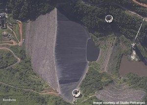
But, at the moment (March 2013), power is the big issue, certainly in Freetown. Not the political sort, although they are related, but the supply of electricity. In November 2009, with great fanfare, President Koroma announced the opening of the Bumbuna hydroelectric power station on the dam of the same name, a graceful creation of Italian engineers. Bumbuna is 100 miles inland from Freetown, up the Seli or Rokel River, which flows roughly west into the Sierra Leone River estuary, and is virtually in the centre of the country. It had been nearly forty years in the making. The plans were unveiled in 1975 but construction ceased from 1997 to 2005 because of the civil war. The 400 metre long Bumbuna dam was designed to solve, first, Freetown’s power problem and, with Phase II, Sierra Leone’s. Phase I, completed in 2009, has two 25 MW Francis turbines, capable of delivering 50 MW in total. Phase II, due for completion in 2017, will increase this to 400 MW.

According to the official statements, Bumbuna could supply all Freetown’s power needs. But the power distribution network was so damaged during the war that Freetown can only handle half of the power that Bumbuna can produce. That corresponds roughly with the observed fact that mains power was available for about half the time. But in recent weeks the mains electricity supply to Freetown has hardly worked at all. Generators, designed to provide power the rest of the time, and as emergency standbys, have been operating almost permanently. So they are starting to break down…
A Presidential statement apparently said that the power outages were because one of the two turbines was broken, and would take a year to fix. Given that the distribution network could only handle half the power produced anyway, one turbine should be quite sufficient, so this does not add up. I suspect that the problem lies with the decrepit distribution network. President Koroma was recently re-elected on the promise of restoring electric power. If he does not get his act together on this one soon, he could be committing political suicide.

The Bumbuna dam
Until such basic issues are sorted out, Sierra Leone will struggle to attract business and tourists. It has stunning resources and has a spectacular, hilly landscape, quite different from the low-lying swampy coast of much of West Africa. And it has some of the most beautiful beaches in the world. The original Bounty bar advert was filmed here in the 1960s (when it was still a British colony). On my fourth night I headed, with the CD, along Lumley Beach. The sun was coming down fast over the sea, first ultramarine, then turning to black, with the white surf spray pounding onto white sand. The currents are strong – this is the Atlantic Ocean – and swimming would be risky. But when we reached the Atlantic Restaurant at the far end of Lumley Beach, we sat looking out at the dark mystery of the Atlantic, under coconut palms blowing in a refreshing, cooling breeze. Next stop – South America. The beauty of the place cannot fail to impress.

We looked at the menu. One great thing about Sierra Leone is that one is not oppressed by freedom of choice. The choice is limited, but everything is very good.
‘The Barracuda’s OK here’, said the CD…
It’s an ill-wind …

Chris Bellamy, Director, Greenwich Maritime Institute

Bumbuna

Train, boat or plane?

As the United Kingdom struggles and overreacts to cope with a few inches of snow, the relative resilience of land, sea and air transport has been put to the test.

On Sunday morning four Eurostar trains were cancelled and there were delays of about half-an hour on all the remaining services as the unfamiliar white stuff forced the 21st-century trains to go more slowly.
At least 300 flights from London’s Heathrow airport, more than a fifth, were cancelled as more snow fell in London. The disruption was set to continue into Monday as Heathrow’s management said it would reduce its capacity by ten percent – about 130 fewer flights.

And the ferries? Channel and North Sea ferry crossings were ‘unaffected’. In the far north, there were warnings of possible disruption to some Scottish ferry sailings off the west and north coasts of mainland Scotland, ‘due to adverse weather conditions’, but as of 10.00 hrs on Monday 21 January, no disruption has been reported.

Well, we’ve been trying to operate planes in snow and ice for about a hundred years, trains for 170 and ships for …perhaps 2,000 out of the 5,000 they have been in existence. When it snows, it clearly shows!

Chris Bellamy.

shutterstock_19903030

Combating Piracy – House of Commons 25 October 2012

‘Why are you here, Sir?’

‘Pirates’

‘Not that Johnny Depp, Sir?’

No – Somali pirates….’

The Met Police security at Portcullis House at 18.30 on Thursday was  rather better humoured (but probably far more effective)  than  most of the security screens you meet.  On Thursday Chris Bellamy attended a meeting chaired by Eric Joyce, MP, ex-British Army and now involved in a number of working parties dealing with piracy – the number one Maritime Security problem at the moment.  There were brief opening talks by journalist  Liz MacMahon from Lloyd’s List  who has written 220 articles on piracy in the past year, and Peter Cook, founder of the Security Association for the Maritime Industry (SAMI), who recently won Lloyd’s List‘s   ‘Newsmaker of the Year’ award.

 The good news was that pirate attacks – and, therefore, successful attacks, in the Indian Ocean and off the east coast of Africa were well down on last year. The not-so-good news was that the proportion  of attacks that were successful had risen, and also that piracy attacks  on the other side of Africa,  in the Gulf of Guinea, had increased.  The decline in attacks in the Indian Ocean could be attributed to successful Naval operations, but also to the longest Monsoon in at least ten years.  The Monsoon was now abating, so this welcome trend might not be irreversible…

Last October David Cameron announced that British-flagged ships would be allowed to carry armed guards.  Peter Cook had been widely quoted as saying that the minimum strength of an armed team – four – should not be reduced in attempts to cut costs.  However, there was another problem.  Although British-flagged ships could now carry armed teams, those teams were in danger of carrying illegal weapons.  Why?  Because the provenance of each weapon – as well as its serial number and other details – had to be squeaky clean.  Many weapons were held in floating armouries – on the High Seas, and therefore out of the jurisdiction of littoral states. This seemed an ideal solution.  But, having allowed British-flagged ships to carry armed teams, the British Government had not got as far as licensing or approving the principal floating armoury whence the weapons could be drawn.  This was at sea off Sri-Lanka, licensed by and operating with the full approval of the Sri  Lanka Government.  The ship itself was joint Mongolian- Sri-Lankan flagged.  In discussion, with several  shipping companies represented, it emerged that there were estimated to be 17-20 floating armouries around the Indian Ocean – mostly Mongolian flagged.  At the moment, however, a British security team drawing weapons from one of these floating armouries would be in breach of the law. If they got into a shooting match with pirates, this could cause a problem.

On the face of it, solving the problem the problem should be quite simple.  Approve the Sri-Lankan- Mongolian floating armoury, and maybe another one at the other (west)  end of the Ocean.  But the subject had so far elicited little interest from the relevant Ministers. Chris suggested that maybe a Parliamentary Question could unlock the problem.

 After  a lively discussion, which also included the problems of charging and trying pirates, the meeting adjourned to ‘the other part of the Palace’.  Portcullis House, built in the 1990s, is linked with the main Houses of Parliament by an underground passage.  The old and the new have been merged skilfully:  1990s tudor-gothic revival with the 1830s gothic revival and pugin.  You descend some stairs, pass between a stone lion and unicorn, and are very quickly passing below Big Ben and into the catacombs below the Palace of Westminster.  A good deal of ‘networking’, appropriately lubricated,  then followed.

Chris Bellamy